
Sandtown, Mississippi
Sandtown, Mississippi | |
|---|---|
 Sandtown, Mississippi  Sandtown, Mississippi | |
| Coordinates: 32°47′41″N 89°00′06″W / 32.79472°N 89.00167°W | |
| Country | United States |
| State | Mississippi |
| County | Neshoba |
| Elevation | 591 ft (180 m) |
| Time zone | UTC-6 (Central (CST)) |
| • Summer (DST) | UTC-5 (CDT) |
| ZIP code | 39350 |
| Area code | 601 |
| GNIS feature ID | 692207[1] |
Sandtown is an unincorporated community located in Neshoba County, Mississippi, United States. Sandtown is approximately 4.7 miles (7.6 km) southwest of Bogue Chitto along Mississippi Highway 482.
References
Municipalities and communities of Neshoba County, Mississippi, United States | ||
|---|---|---|
| Cities | 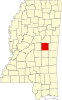 | |
| Town | ||
| CDPs | ||
| Other communities | ||
| Indian reservation | ||
| Footnotes | ‡This populated place also has portions in an adjacent county or counties | |
This Mississippi location article is a stub. You can help Wikipedia by expanding it. |