
Smithburg, West Virginia
Smithburg, West Virginia | |
|---|---|
| Nickname: Home of the Thellers | |
 Smithburg Location within the state of West Virginia  Smithburg Smithburg (the United States) | |
| Coordinates: 39°17′21″N 80°44′4″W / 39.28917°N 80.73444°W | |
| Country | United States |
| State | West Virginia |
| County | Doddridge |
| Time zone | UTC-5 (Eastern (EST)) |
| • Summer (DST) | UTC-4 (EDT) |
| ZIP codes | 26436 |
| FIPS code | 1547006[1] |
Smithburg is an unincorporated community in Doddridge County in the U.S. state of West Virginia. It is located along U.S. Route 50. Middle Island Creek, the longest stream in West Virginia to be named a "creek,"[2] is formed in Smithburg by the confluence of Meathouse Fork and Buckeye Creek.[3] The North Bend Rail Trail passes through the community.
References
- ^ U.S. Geological Survey Geographic Names Information System: Smithburg, West Virginia
- ^ The West Virginia Enclyclopedia: Jug of Middle Island Creek, accessed 2013-12-14
- ^ The National Map, accessed 2013-12-14
Municipalities and communities of Doddridge County, West Virginia, United States | ||
|---|---|---|
| Town | 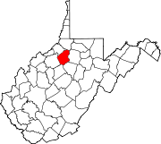 | |
| Unincorporated communities | ||
This article about a location in Doddridge County, West Virginia is a stub. You can help Wikipedia by expanding it. |