
Springhill, Faulkner County, Arkansas
Springhill, Arkansas | |
|---|---|
 Springhill  Springhill | |
| Coordinates: 35°11′19″N 92°23′33″W / 35.18861°N 92.39250°W | |
| Country | United States |
| State | Arkansas |
| County | Faulkner |
| Elevation | 367 ft (112 m) |
| Time zone | UTC-6 (Central (CST)) |
| • Summer (DST) | UTC-5 (CDT) |
| Area code | 501 |
| GNIS feature ID | 78437[1] |
Springhill is an unincorporated community in Faulkner County, Arkansas, United States. The community is located at the junction of U.S. Route 65 and Arkansas Highway 287, 3 miles (4.8 km) south of Greenbrier.[2]
The Titan II ICBM Launch Complex 374-5 Site, which is listed on the National Register of Historic Places, is near the community.[3]
Education
Public education for elementary and secondary school students is primarily provided by the Greenbrier School District, beginning at the district's Springhill Elementary School and leading to graduation from Greenbrier High School.
References
- ^ "Springhill". Geographic Names Information System. United States Geological Survey, United States Department of the Interior.
- ^ Faulkner County, Arkansas General Highway Map (PDF) (Map). Arkansas State Highway and Transportation Department. September 11, 2014. Retrieved April 9, 2016.
- ^ "National Register Information System". National Register of Historic Places. National Park Service. July 9, 2010.
Municipalities and communities of Faulkner County, Arkansas, United States | ||
|---|---|---|
| Cities | 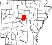 | |
| Towns | ||
| Unincorporated communities | ||
| Footnotes | ‡This populated place also has portions in an adjacent county or counties | |
This Arkansas state location article is a stub. You can help Wikipedia by expanding it. |