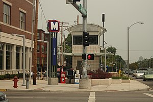
Skinker station
Appearance
Skinker | |||||||||||
|---|---|---|---|---|---|---|---|---|---|---|---|
| MetroLink light rail station | |||||||||||
 | |||||||||||
| General information | |||||||||||
| Location | 260 North Skinker Boulevard St. Louis, Missouri 63112 | ||||||||||
| Coordinates | 38°38′58″N 90°18′03″W / 38.649414°N 90.30082°W | ||||||||||
| Owned by | Bi-State Development Agency | ||||||||||
| Operated by | Metro Transit | ||||||||||
| Tracks | 2 | ||||||||||
| Connections | |||||||||||
| Construction | |||||||||||
| Structure type | Underground | ||||||||||
| Accessible | Yes | ||||||||||
| History | |||||||||||
| Opened | August 26, 2006 | ||||||||||
| Passengers | |||||||||||
| 2007 | 736 daily | ||||||||||
| Services | |||||||||||
| |||||||||||
The Skinker St. Louis MetroLink light rail station opened August 26, 2006 at the intersection of Skinker Boulevard and Forest Park Parkway near the boundary of St. Louis and University City, and serves the eastern portion of the Washington University main campus, the western portion of Forest Park, and area residents in the Skinker-DeBaliviere Neighborhood. It is a below-grade station, located under Skinker Boulevard at Forest Park Parkway, adjacent to Kayak's.
Station layout
| G | Street level | Entrance/exit and buses |
| P Platform level |
Side platform, doors will open on the right | |
| Westbound | ← Blue Line toward Shrewsbury – Lansdowne (University City – Big Bend) | |
| Eastbound | Blue Line toward Fairview Heights (Forest Park – DeBaliviere) → | |
| Side platform, doors will open on the right | ||
External links
Categories:
- MetroLink stations in St. Louis
- Blue Line (St. Louis MetroLink)
- Railway stations located underground in Missouri
- Railway stations in Missouri at university and college campuses
- Metro Transit (St. Louis) stubs
- Midwestern United States railway station stubs
- Missouri building and structure stubs
- Missouri transportation stubs
- St. Louis building and structure stubs
