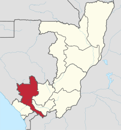
Niari Department
Appearance
Niari | |
|---|---|
 Niari, department of the Republic of the Congo | |
| Country | Republic of the Congo |
| Capital | Dolisie |
| Area | |
| • Total | 25,942 km2 (10,016 sq mi) |
| Population (2007 census) | |
| • Total | 231,271 |
| • Density | 8.9/km2 (23/sq mi) |
| HDI (2018) | 0.567[1] medium · 4th of 12 |
Niari is a department of the Republic of the Congo in the western part of the country. It borders the departments of Bouenza, Kouilou, and Lékoumou, and internationally, Gabon, the Democratic Republic of the Congo, and the Cabinda portion of Angola. The regional capital is Dolisie.

Niari according to an administrational reorganisation of 2012 is divided into 13 districts and 2 communes not belonging to any district:
Districts
- Banda
- Divénié
- Kibangou
- Kimongo
- Londéla-Kayes
- Louvakou
- Mbinda
- Moungoundou Nord
- Moungoundou Sud
- Moutamba
- Mayoko
- Nianga
- Yaya
Communes
References
- ^ "Sub-national HDI - Area Database - Global Data Lab". hdi.globaldatalab.org. Retrieved 2018-09-13.
4°12′S 12°40′E / 4.200°S 12.667°E
