
Skreia
Skreia | |
|---|---|
.JPG) Skreia seen from Balke | |
 Skreia | |
| Coordinates: 60°39′N 10°56′E / 60.650°N 10.933°E | |
| Country | Norway |
| Municipality | Østre Toten |
| Time zone | UTC+01:00 (CET) |
| • Summer (DST) | UTC+02:00 (CEST) |
Skreia is a village in the municipality of Østre Toten, Innlandet county, Norway.[1]
Skreia was the terminus of Skreia Line (Skreiabanen), an abandoned railway line which once ran between Reinsvoll and Skreia. The single track rail was a branch line from the Gjøvik Line and was closed in 1987. Skreia is located along Fylkesvei 33 which runs between Bjørgo in Nord-Aurdal and Minnesund in Eidsvoll. Ostre Toten Cultural Center (Østre Toten kulturhus)is located in Skreia. The principal local industry is food production and the processing of potatoes and vegetables. The village had a population of 1,041 inhabitants as of 1 January 2015.[2][3]
Notable residents
- Alv Gjestvang, speed skater
- Inger Lise Rypdal, singer
- Maj Britt Andersen, singer
Gallery
-
 Skreia Bridge
 -
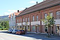
 Skreia Main Street
 -
 Center of Skreia
 -
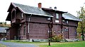 Skreia Railway Station
 -
 Østre Toten Cultural Center


References
- ^ Rune Nedrud. "Skreia – tettsted". Store norske leksikon. Retrieved October 1, 2016.
- ^ Tor Wisting. "Skreiabanen". Store norske leksikon. Retrieved October 1, 2016.
- ^ "Østre Toten kulturhus". Østre Toten kommune. Retrieved October 1, 2016.
This Innlandet location article is a stub. You can help Wikipedia by expanding it. |