
Canterbury Hospital
| Canterbury Hospital | |
|---|---|
| Sydney Local Health District | |
 | |
| Geography | |
| Location | 575 Canterbury Road, Campsie, Sydney, NSW, Australia |
| Coordinates | 33°55′11″S 151°05′54″E / 33.9196°S 151.0984°E |
| Organisation | |
| Care system | Public Medicare (AU) |
| Type | Teaching |
| Affiliated university | The University of Sydney |
| Services | |
| Emergency department | Yes |
| Beds | 217 |
| Speciality | Maternity, geriatrics, general medicine |
| History | |
| Opened | 1929 |
| Links | |
| Website | Official Website |
| Lists | Hospitals in Australia |
The Canterbury Hospital is a metropolitan hospital in Campsie, a south-western suburb of Sydney, New South Wales, Australia.
Canterbury Hospital was opened in 1929 and was rebuilt in 1998.
Canterbury Hospital is one of many hospitals in a network under the management of Sydney Local Health District. Canterbury Hospital has links to Concord Repatriation General Hospital, Royal Prince Alfred Hospital and the University of Sydney, offering health services to residents in the Canterbury and Bankstown area of Sydney.
Canterbury Hospital and community health centre cater for a local population of 220,000 of which 66% come from non-English speaking backgrounds.[citation needed]
Gallery
-
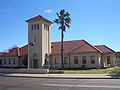 Old Canterbury Hospital building
 -
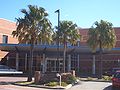 Canterbury Hospital entrance
 -
 A black and white painting entitled Canterbury Memorial Hospital, by the Government Architect, whose signature is illegible.


See also
References
External links
This hospital in Australia-related article is a stub. You can help Wikipedia by expanding it. |
This article about a building or structure in New South Wales is a stub. You can help Wikipedia by expanding it. |