
Skytrail
Skytrail | |
|---|---|
 | |
| Coordinates | 51°29′24.53″N 107°4′20.83″W / 51.4901472°N 107.0724528°W |
| Carries | Pedestrian (current) Railway (former) |
| Crosses | South Saskatchewan River |
| Locale | Outlook, Saskatchewan, Canada |
| Characteristics | |
| Design | Truss bridge |
| Material | Steel |
| Total length | 3,000 feet (910 m) |
| Height | 150 feet (46 m) |
| History | |
| Designer | J.D. McArthur and Company |
| Construction start | January 24, 1910 |
| Construction end | October 23, 1912 |
| Opened | October 23, 1912 |
| Closed | March 16th, 1987 (railway) |
| Location | |
 | |
The Skytrail Bridge spans the South Saskatchewan River in Outlook, Saskatchewan, Canada. It was originally built by the Canadian Pacific Railway over the full width of the river's flood channel and has eight spans.[1] It served as a railway bridge from October 23, 1912, until March 16, 1987. In 2003 it was converted to a pedestrian bridge and is now the longest pedestrian bridge in Canada.[2] The bridge is part of the Trans-Canada Trail. Due to structural issues, the bridge has been closed since late 2013.
-
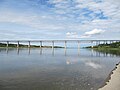 A panorama view of the Skytrail
 -
 View from below the bridge


See also
References
- ^ Smith, C.D. (1984). "Scour control at Outlook Bridge-A case study". Can. J. Civ. Eng. 11 (4). NRC Research Press: 709–716. doi:10.1139/l84-091.
- ^ SkyTrail - Canada's Longest Pedestrian Bridge