Balakliia Raion
Balakliia Raion
Балаклійський район | |
|---|---|
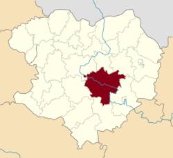
 Raion location in Kharkiv Oblast | |
| Coordinates: 49°24′27.1476″N 36°51′17.715″E / 49.407541000°N 36.85492083°E | |
| Country | Ukraine |
| Oblast | Kharkiv Oblast |
| Admin. center | Balakliia |
| Area | |
| • Total | 1,986.44 km2 (766.97 sq mi) |
| Population (2018) | |
| • Total | 80 487[1] |
| Time zone | UTC+2 (EET) |
| • Summer (DST) | UTC+3 (EEST) |
| Website | http://balakliya-rda.gov.ua/ |
Balakliia Raion (Ukrainian: Балаклійський район) is the largest raion (district) in Kharkiv Oblast of Ukraine. The area of the raion is 1,986.4 km², corresponding to 6.3% of the total territory of Kharkiv Oblast. Its administrative center is the town of Balakliia.
References
- ^ Чисельність населення (за оцінкою) на 1 січня 2018 року // Головне управління статистики у Харківській області


