Hadstock
| Hadstock | |
|---|---|
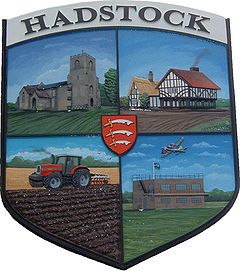
 Hadstock village sign | |
Location within Essex | |
| Population | 332 (2011 Census)[1] |
| OS grid reference | TL558448 |
| Civil parish |
|
| District | |
| Shire county | |
| Region | |
| Country | England |
| Sovereign state | United Kingdom |
| Post town | Cambridge |
| Postcode district | CB21 |
| Dialling code | 01223 |
| Police | Essex |
| Fire | Essex |
| Ambulance | East of England |
| UK Parliament | |
Hadstock is a village in Essex, England, about 6 miles (10 km) from Saffron Walden. It is on the county boundary with Cambridgeshire and about 9 miles (14 km) from Cambridge. The 2001 Census recorded a parish population of 320,[2] increasing to 332 at the 2011 Census.[1]
The Church of England parish church of Saint Botolph has the oldest door still in use in Great Britain. The oldest parts of the church are thought to date from about AD 1020. Since that time the church has received many additions and undergone several renovations.
On the outskirts of the village is a disused airfield that was used in World War II. While the official name for the airfield became RAF Little Walden, it was originally named after the village of Hadstock.
Hadstock has a silver band.[3]
See also
References
- ^ a b "Parish population 2011". Neighbourhood Statistics. Office for National Statistics. Retrieved 25 September 2015.
- ^ Office for National Statistics: 2001 Census. Retrieved 13 March 2011.
- ^ Hadstock Silver Band
External links
![]() Media related to Hadstock at Wikimedia Commons
Media related to Hadstock at Wikimedia Commons

