Markelfinger Winkel
Appearance
| Markelfinger Winkel | |
|---|---|
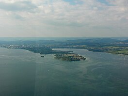
 Aerial photograph of the Gnadensee (with the Mettnau peninsula behind) and its continuation, the Markelfinger Winkel | |
| Location | Baden-Württemberg |
| Coordinates | 47°44′17″N 08°59′40″E / 47.73806°N 8.99444°E |
| Primary inflows | Östlicher Sibach |
| Primary outflows | Gnadensee |
| Max. length | 1.44 kilometres (0.89 mi) |
| Max. width | 0.98 kilometres (0.61 mi) |
| Surface area | 1.06 kilometres (0.66 mi)2 |
| Shore length1 | 4 kilometres (2.5 mi) |
| 1 Shore length is not a well-defined measure. | |
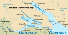
The Markelfinger Winkel is that part of Lake Constance between the upper part of the Mettnau peninsula and Markelfingen. It is the northwestern continuation of the Gnadensee and its parent lake, the Untersee ("Lower Lake Constance"). It has an area of around one square kilometre.[1]
References
- ^ Bodensee: Teilseen und Rheinmündung Archived 2015-02-18 at the Wayback Machine (map)


