
Jarnioux
Jarnioux | |
|---|---|
Part of Porte des Pierres Dorées | |
 The chateau and the church in Jarnioux | |
.svg) Coat of arms | |
Location of Jarnioux  | |
 Jarnioux  Jarnioux | |
| Coordinates: 45°57′56″N 4°37′41″E / 45.9656°N 4.6281°E | |
| Country | France |
| Region | Auvergne-Rhône-Alpes |
| Department | Rhône |
| Arrondissement | Villefranche-sur-Saône |
| Canton | Le Bois-d'Oingt |
| Commune | Porte des Pierres Dorées |
| Area 1 | 4.2 km2 (1.6 sq mi) |
| Time zone | UTC+01:00 (CET) |
| • Summer (DST) | UTC+02:00 (CEST) |
| Postal code | 69640 |
| Elevation | 259–393 m (850–1,289 ft) (avg. 330 m or 1,080 ft) |
| 1 French Land Register data, which excludes lakes, ponds, glaciers > 1 km2 (0.386 sq mi or 247 acres) and river estuaries. | |
Jarnioux is a former commune in the Rhône department in eastern France. On 1 January 2019, it was merged into the commune Porte des Pierres Dorées.[1]
Places and monuments
Jarnioux has several monuments :
- The manor of the Guard (private, rental of rooms for events).
- The castle of Jarnioux.
- The Sainte Catherine chapel.
- The flag of the Holy Spirit and the stele linked to the Heiho Niten Ichi Ryu Memorial.
- The viaduct of the old Beaujolais railway (Tacot).
The Alliance Socle established in Liergues in front of the Tsuji castle links the 32 municipalities of the Porte des Pierres Dorées including the municipality of Jarnioux within the Auvergne Rhône-Alpes Dauphiné Savoie region with the Prefecture of Okayama and the city of Mimasaka in Japan.
-
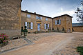 Interior facade of the Manoir de La Garde.
 -
 Castle of Jarnioux.
 -
 Alliance Socle in front of the Tsuji castle in the Porte des Pierres dorées link between Okayama prefecture and Mimasaka and Auvergne Rhône-Alpes Dauphiné Savoie Region.
 -
 Flag and stele linked to the Heiho Niten Ichi Ryu Memorial, and Sainte Catherine chapel.
 -
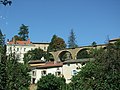 The viaduc of the Tacot.


Personalities linked to the municipality
Auguste Guinon transformed Jarnioux from 1869. He equipped the village with a wash house, a town hall, a school and a church.
Serge Prisset, singer known for the song "Colombe ivre", released in 1970. He lives in Jarnioux.
See also
References
- ^ Arrêté préfectoral 28 September 2018 (in French)
External links
| National | |
|---|---|
| Geographic | |
This Rhône geographical article is a stub. You can help Wikipedia by expanding it. |