
Kaub
Kaub | |
|---|---|
 Kaub | |
 Coat of arms | |
Location of Kaub within Rhein-Lahn-Kreis district  | |
 Kaub  Kaub | |
| Coordinates: 50°5′17″N 7°45′46″E / 50.08806°N 7.76278°E | |
| Country | Germany |
| State | Rhineland-Palatinate |
| District | Rhein-Lahn-Kreis |
| Municipal assoc. | Loreley |
| Government | |
| • Mayor | Heribert Werr |
| Area | |
| • Total | 12.98 km2 (5.01 sq mi) |
| Elevation | 90 m (300 ft) |
| Population (2022-12-31)[1] | |
| • Total | 828 |
| • Density | 64/km2 (170/sq mi) |
| Time zone | UTC+01:00 (CET) |
| • Summer (DST) | UTC+02:00 (CEST) |
| Postal codes | 56349 |
| Dialling codes | 06774 |
| Vehicle registration | EMS |
| Website | www.kaubamrhein.de |
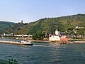
Kaub (old spelling: Caub) is a town in Germany, state Rhineland-Palatinate, district Rhein-Lahn-Kreis. It is part of the municipality (Verbandsgemeinde) Loreley. It is located on the right bank of the Rhine, approx. 50 km west from Wiesbaden. It is connected to Wiesbaden and Koblenz by railway. Population 1100. It has a Roman Catholic and an Evangelical church, and a statue of General Blücher. The trade mainly consists of the wines of the district.
Kaub is known for the castle Pfalz, or Burg Pfalzgrafenstein, situated on a rock in the middle of the Rhine. According to legend, the Palatine countesses awaited their confinement in the Pfalz, but in reality the castle served as a toll-gate for merchandise on the Rhine. The restored castle Gutenfels sits on a hill above the town.
Kaub, first mentioned in the year 983, originally belonged to the lords of Falkenstein, in 1260 the Counts of Katzenelnbogen divided their county and selected the inhabitants of Kaub, then passed in 1277 to the Rhenish Electorate of the Palatinate, and attained civic rights in 1324. In 1477 Kaub was passed as deposit to the Counts of Katzenelnbogen again. In 1479 this family died out.[2] It was at Kaub that Blücher crossed the Rhine with the Prussian and Russian armies, on New Years night 1813–1814, in pursuit of the French.
Mayors
The honorary mayor is since 2009 Karl-Heinz Lachmann (SPD). From 1989 to 2009 Heribert Werr (KBL) was the mayor. [3][4] Lachmann was reelected in 2014.[5]

Kaub was part of the temporary state Free State Bottleneck from 1919 to 1923.
Gallery
-
 Kaub, with the castles Pfalzgrafenstein and Burg Gutenfels
 -
 Castles Pfalzgrafenstein & Gutenfels
 -
 Castle Pfalzgrafenstein
 -
 Kaub & Castle Pfalzgrafenstein


Notes and references
- ^ "Bevölkerungsstand 2022, Kreise, Gemeinden, Verbandsgemeinden" (PDF) (in German). Statistisches Landesamt Rheinland-Pfalz. 2023.
- ^ http://www.graf-von-katzenelnbogen.de/ Kaub, The County of Katzenelnbogen and the First Riesling of the World
- ^ fr-online vom 26. Juni 2009: Bürgermeisterwahl in Kaub: SPD im Glück
- ^ "Statistisches Landesamt: Direktwahlen der Orts- und Stadtbürgermeister sowie der Ortsvorsteher". Archived from the original on 2016-11-16. Retrieved 2017-03-05.
- ^ http://www.wahlen.rlp.de/kw/dw/direkt_ab_2009/Ortsbuergermeister/1410000000.htm[permanent dead link]
- Picture of Pfalzgrafenstein, J.F. Dielmann, A. Fay, J. Becker (painter): F.C. Vogels Panorama des Rheins, Bilder des rechten und linken Rheinufers, Lithographische Anstalt F.C. Vogel, Frankfurt 1833
- Picture of Kaub, J.F. Dielmann, A. Fay, J. Becker (painter): F.C. Vogels Panorama des Rheins, Bilder des rechten und linken Rheinufers, Lithographische Anstalt F.C. Vogel, Frankfurt 1833
- Picture 2 of Kaub, J.F. Dielmann, A. Fay, J. Becker (painter): F.C. Vogels Panorama des Rheins, Bilder des rechten und linken Rheinufers, Lithographische Anstalt F.C. Vogel, Frankfurt 1833
This article incorporates text from a publication now in the public domain: Chisholm, Hugh, ed. (1911). "Caub". Encyclopædia Britannica. Vol. 5 (11th ed.). Cambridge University Press. pp. 545–546.
External links
 Kaub travel guide from Wikivoyage

| International | |
|---|---|
| National | |
This Rhein-Lahn location article is a stub. You can help Wikipedia by expanding it. |