Dolany nad Vltavou
Appearance
You can help expand this article with text translated from the corresponding article in Czech. (July 2009) Click [show] for important translation instructions.
|
Dolany (Mělník District) | |
|---|---|
Village | |
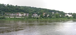
 Look over Vltava river | |
 | |
| Country | |
| Region | Central Bohemian Region |
| District | Mělník District |
| Government | |
| • Mayor | Josef Drápela |
| Area | |
| • Total | 2.1 sq mi (5.5 km2) |
| Elevation | 630 ft (192 m) |
| Population (2018) | |
| • Total | 902 |
| • Density | 420/sq mi (160/km2) |
| Time zone | UTC+1 (CET) |
| • Summer (DST) | UTC+2 (CEST) |
| Website | https://www.dolany.cz/ |
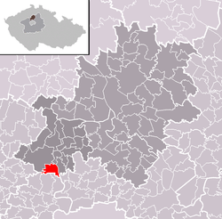
Dolany nad Vltavou (until 2016 Dolany) is situated in the Mělník district, the Central Bohemian region, on the left bank of the river Vltava, approximately 3 km southeast of Kralupy nad Vltavou. It has a population of 902 inhabitants. The village is situated along the shore in the place, where the rocky valley of the Vltava ends and begins a plain typical for the confluence of the river Vltava and Labe. The village also belongs village Debrno, which is located less than 2 kilometers away from Dolany.
References
- This article was initially translated from the Czech Wikipedia.
50°13′11″N 14°20′31″E / 50.2197°N 14.3419°E


