Kráľová pri Senci
Appearance
Kráľová pri Senci | |
|---|---|
Municipality | |
 Saint John the Baptist Church | |
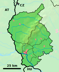
Location of Kráľová pri Senci in the Bratislava Region | |
| Coordinates: 48°12′N 17°27′E / 48.200°N 17.450°E | |
| Country | Slovakia |
| Region | Bratislava |
| District | Senec |
| First mentioned | 1363 |
| Area | |
| • Total | 19.912 km2 (7.688 sq mi) |
| Elevation | 128 m (420 ft) |
| Population (2004) | |
| • Total | 1,426 |
| • Density | 72/km2 (190/sq mi) |
| Postal code | 900 50 |
| Area code | 421-2 |
| Car plate | SC |
| Website | www.kralovaprisenci.sk |
Kráľová pri Senci (Hungarian: Királyfa, meaning King Tree) is a village and municipality in western Slovakia in Senec District in the Bratislava Region.

History
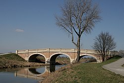
The village was first mentioned in 1363, it was royal property, hence probably the name. The most significant landmark of village is secession bridge over the river Čierna voda, which was built in 1904 and it imitates baroque architecture.
Geography
The village lies at an altitude of 128 metres and covers an area of 19.912 km². It has a population of 1426 people (as of 2004).
External links
![]() Media related to Kráľová pri Senci at Wikimedia Commons
Media related to Kráľová pri Senci at Wikimedia Commons
- Municipal website (in Slovak)
- https://web.archive.org/web/20080111223415/http://www.statistics.sk/mosmis/eng/run.html


