Guaviare River
| Guaviare | |
|---|---|
 The Guaviare River as seen from space | |
| Location | |
| Country | Colombia |
| Physical characteristics | |
| Source | |
| • location | Arriari and Guayabero Rivers |
| Mouth | |
• location | The Orinoco |
| Length | 1,497 km (930 mi) |

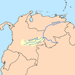
The Guaviare is a tributary of the Orinoco in Colombia.
The Guaviare has its source in two other rivers, the Arriari and the Guayabero, which in turn have their own sources in the eastern part of the Andes. At 1,497 kilometres (930 mi) long, it is the longest tributary of the Orinoco and is navigable for 630 kilometres (390 mi) of its total length. The Guaviare is considered the border between the Llanos and the Amazon Rainforest. Its main tributary is the Inírida River.
References
- The information in this article is based on a translation of its German equivalent.
External links
4°02′34″N 67°42′41″W / 4.0427°N 67.7115°W

