
Mórichida
Mórichida
Mursella (in Latin) | |
|---|---|
 St. James Church, Lutheran church, Marcal river bank, Kaszalapi Lake, Marcal River | |
 Flag  Coat of arms | |
 Mórichida Location of Mórichida | |
| Coordinates: 47°30′45″N 17°25′17″E / 47.51246°N 17.42147°E | |
| Country | |
| County | Győr-Moson-Sopron |
| Area | |
• Total | 32.31 km2 (12.47 sq mi) |
| Population (2013) | |
• Total | 818 |
| • Density | 2,591/km2 (6,710/sq mi) |
| Time zone | UTC+1 (CET) |
| • Summer (DST) | UTC+2 (CEST) |
| Postal code | 9131 |
| Area code | 96 |
Mórichida is a village in Győr-Moson-Sopron county, Hungary. The north-western part of Hungary, the Little Plain, the Marcal and Raba valley away. Right bank of the River Marcal.
Sights
- St. Jacob church (1251)
- Lutheran church (1789)
- Vineyards (1814)
- Nature: Rába, Marcal, Kaszalapi Lake
-
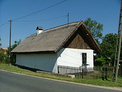 Old house
 -
 Csángota


Born in Mórichida
- Fehér Dániel (Nagymórichida–Tekepuszta, 1890. – Sopron, 1955.) Forest engineer, microbiologist, plant physiologist, botanist.
External links
- Street map (in Hungarian)
This Győr-Moson-Sopron location article is a stub. You can help Wikipedia by expanding it. |