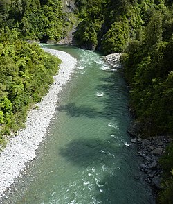
Waiohine River
Appearance
| Waiohine River | |
|---|---|
 Waiohine River in Waiohine Gorge | |
 | |
| Location | |
| Country | New Zealand |
| Physical characteristics | |
| Source | |
| • location | Lancaster Peak, Tararua Range |
| • elevation | 1,500 m (4,920 ft) |
| Mouth | |
• location | Ruamahanga River at Pāpāwai |
• elevation | 40 m (130 ft) |
| Length | 35 km (22 mi) |
| Basin size | 378 km2 (146 sq mi) |
| Discharge | |
| • average | 25 m3/s (880 cu ft/s) at Waiohine Gorge |
The Waiohine River is a river of the Greater Wellington Region of New Zealand's North Island.
At first it flows generally south from its origins in the Tararua Range west of Otaki. It turns south-east once it reaches the plain where it passes to the north of Greytown and flows into the Ruamahanga River at Pāpāwai.
Some of its water reaches Lake Wairarapa directly through many channels and irrigation features in Greytown's fruit-growing district.
See also
References
Wikimedia Commons has media related to Waiohine River.
- "Place name detail: Waiohine River". New Zealand Gazetteer. New Zealand Geographic Board. Retrieved 12 July 2009.
41°05′14″S 175°30′15″E / 41.08722°S 175.50417°E
