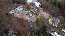
Schleiden
Appearance
Schleiden | |
|---|---|
Location of Schleiden within Euskirchen district  | |
| Coordinates: 50°31′59″N 06°28′00″E / 50.53306°N 6.46667°E | |
| Country | Germany |
| State | North Rhine-Westphalia |
| Admin. region | Köln |
| District | Euskirchen |
| Government | |
| • Mayor | Ingo Pfennings (CDU) |
| Area | |
| • Total | 122.09 km2 (47.14 sq mi) |
| Elevation | 456 m (1,496 ft) |
| Population (2023-12-31)[1] | |
| • Total | 13,233 |
| • Density | 110/km2 (280/sq mi) |
| Time zone | UTC+01:00 (CET) |
| • Summer (DST) | UTC+02:00 (CEST) |
| Postal codes | 53937 |
| Dialling codes | 02445 |
| Vehicle registration | EU, SLE |
| Website | www.schleiden.de |
Schleiden is a town in North Rhine-Westphalia, Germany. It lies in the Eifel hills, in the district of Euskirchen, and has 12,998 inhabitants as of 30 June 2017.[2] Schleiden is connected by a tourist railway to Kall, on the Eifel Railway between Cologne and Trier. The town consists of 18 settlements, the largest of which are Gemünd and Schleiden proper.
History
Historical affiliations
County of Luxembourg 1271–1353
Duchy of Luxembourg 1353–1795
French Republic 1795–1804
French Empire 1804–1815
Kingdom of Prussia 1815–1871
German Empire 1871–1918
Weimar Republic 1918–1933
Nazi Germany 1933–1945
Allied-occupied Germany 1945–1949
West Germany 1949–1990
Germany 1990–present
Mayors
- 1972−1975: Max Fesenmeyer (independent)
- 1975−1984: Herbert Hermesdorf (1914-1999) (CDU)
- 1984−1995: Alois Sommer (CDU)
- 1995−1997: Dieter Wolter (CDU)
- 1997−2004: Christoph Lorbach (CDU)
- 2004−2012: Ralf Hergarten (independent)
- since 2012: Udo Meister (FDP)
Education
There are the following schools in the city:
- Municipal High School
- Clara-Fey-High School, Schleiden (carrier is the diocese of Aachen)
- Municipal Secondary School
- Primary school
- Elementary school
- Elementary school Gemünd
- Elementary school Dreiborn
- Astrid Lindgren School, Schleiden

Public figures

- Johannes Sturm (Sturmius) (1507–1589), educator and scholar of the Renaissance, a professor in Paris and founder of the University of Strasbourg
- Johannes Sleidanus (1506–1556), historian, professor, Schleiden / Strasbourg
- Leopold Schoeller (1792–1884), industrialist and Privy Councillor of Commerce
- Gustav Poensgen (1824–1904), industrialist and Privy Councillor of Commerce
- Rudolf Poensgen (1826–1895), industrialist and councillor of commerce
- Carl Poensgen (1838–1921), industrialist and Privy Councillor of Commerce
- Larres Albert (1900–1987), painter
- Francis Albert Heinen (born 1953), journalist and nonfiction writer
- George Schreiber (born 1958), photographer
- Vera Hilger (born 1971), painter
References
- ^ "Bevölkerung der Gemeinden Nordrhein-Westfalens am 31. Dezember 2023 – Fortschreibung des Bevölkerungsstandes auf Basis des Zensus vom 9. Mai 2011" (in German). Landesbetrieb Information und Technik NRW. Retrieved 2024-06-20.
- ^ "Einwohnerzahlen im Regierungsbezirk Köln". Information und Technik Nordrhein-Westfalen: Statistik. it.nrw.de (accessed 24 June 2018).
- ^ http://www.schleiden.de/sv_schleiden/Rathaus/Rathaus%20&%20Politik/Rathaus/Verwaltungsorganisation/Verwaltungsf%C3%BChrung%20seit%201972 administration since 1972 homepage of the town Schleiden


