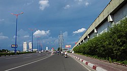
Saigon 2 Bridge
Appearance
This article needs additional citations for verification. (September 2016) |
Saigon 2 Bridge Cầu Sài Gòn 2 | |
|---|---|
 | |
| Coordinates | 10°47′56″N 106°43′38″E / 10.79889°N 106.72722°E |
| Crosses | Saigon River |
| Locale | Ho Chi Minh City, Vietnam |
| Characteristics | |
| Material | Concrete |
| Total length | 987.3 metres (3,239 ft) |
| Width | 23.5 metres (77 ft) |
| History | |
| Opened | 15 October 2013 |
| Statistics | |
| Toll | no |
| Location | |
 | |
Saigon 2 Bridge (Cầu Sài Gòn 2) is a bridge crossing the Saigon River, connecting Bình Thạnh District and District 2, Ho Chi Minh City, on the Hanoi Highway. It is parallel to the Saigon Bridge, being 3 metres south of it and carrying traffic in the eastern direction. Congestion on the old Saigon Bridge required increased traffic capacity, with the new bridge doubling the number of lanes, carrying another 4 lanes plus a 2 lanes for motorbikes. The cost of the bridge was 1,259,000,000,000 Vietnamese đồng.[1] Construction started in April 2012, and the bridge was opened for traffic in October 2013.[2]
References
