
Mount Olive, Coosa County, Alabama
Mount Olive, Alabama | |
|---|---|
 Mount Olive | |
| Coordinates: 33°04′10″N 86°08′06″W / 33.06944°N 86.13500°W | |
| Country | United States |
| State | Alabama |
| County | Coosa |
| Area | |
| • Total | 8.322 sq mi (21.55 km2) |
| • Land | 8.319 sq mi (21.55 km2) |
| • Water | 0.003 sq mi (0.008 km2) |
| Elevation | 823 ft (251 m) |
| Population | |
| • Total | 371 |
| • Density | 45/sq mi (17/km2) |
| Time zone | UTC-6 (Central (CST)) |
| • Summer (DST) | UTC-5 (CDT) |
| Area code(s) | 256 & 938 |
| FIPS code | 01-52320 |
| GNIS feature ID | 160159[3] |
Mount Olive is a census-designated place in Coosa County, Alabama, United States. Its population was 371 as of the 2010 census.[4]
References
- ^ "US Gazetteer files: 2010, 2000, and 1990". United States Census Bureau. 2011-02-12. Retrieved 2011-04-23.
- ^ "U.S. Census website". United States Census Bureau. Retrieved 2011-05-14.
- ^ "Mount Olive". Geographic Names Information System. United States Geological Survey, United States Department of the Interior.
- ^ "Geographic Identifiers: 2010 Demographic Profile Data (G001): Mount Olive CDP (Coosa County), Alabama". U.S. Census Bureau, American Factfinder. Archived from the original on February 12, 2020. Retrieved June 9, 2014.
Municipalities and communities of Coosa County, Alabama, United States | ||
|---|---|---|
| Towns | 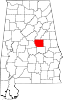 | |
| CDPs | ||
| Other unincorporated communities | ||
| Footnotes | ‡This populated place also has portions in an adjacent county or counties | |
This Alabama state location article is a stub. You can help Wikipedia by expanding it. |