
Adams Township, Miner County, South Dakota
Adams Township, South Dakota | |
|---|---|
| Coordinates: 44°4′24″N 97°32′26″W / 44.07333°N 97.54056°W | |
| Country | United States |
| State | South Dakota |
| County | Miner |
| Area | |
| • Total | 36.0 sq mi (93.2 km2) |
| • Land | 36.0 sq mi (93.2 km2) |
| • Water | 0.0 sq mi (0.0 km2) |
| Elevation | 1,578 ft (481 m) |
| Population (2000) | |
| • Total | 125 |
| • Density | 3.5/sq mi (1.3/km2) |
| Time zone | UTC-6 (Central (CST)) |
| • Summer (DST) | UTC-5 (CDT) |
| Area code | 605 |
| FIPS code | 46-00300[1] |
| GNIS feature ID | 1267727[2] |
Adams Township is a township in Miner County, South Dakota, United States.
References
- ^ "U.S. Census website". United States Census Bureau. Retrieved 2008-01-31.
- ^ "US Board on Geographic Names". United States Geological Survey. 2007-10-25. Retrieved 2008-01-31.
Municipalities and communities of Miner County, South Dakota, United States | ||
|---|---|---|
| Cities | 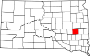 | |
| Towns | ||
| Township | ||
| CDPs | ||
| Ghost town |
| |
This South Dakota state location article is a stub. You can help Wikipedia by expanding it. |