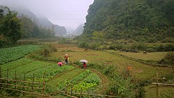
Trùng Khánh district
Appearance
You can help expand this article with text translated from the corresponding article in Vietnamese. (March 2009) Click [show] for important translation instructions.
|
Trùng Khánh District
Huyện Trùng Khánh | |
|---|---|
 | |
| Country | |
| Region | Northeast |
| Province | Cao Bằng |
| Capital | Trùng Khánh |
| Area | |
| • Total | 265.64 sq mi (688.01 km2) |
| Population (2019) | |
| • Total | 70,424 |
| • Density | 260/sq mi (102/km2) |
| Time zone | UTC+7 (Indochina Time) |
Trùng Khánh is a district (huyện) of Cao Bằng Province in the Northeast region of Vietnam.
As of 2019 the district had a population of 70,424.[1] The district covers an area of 688.01 km². The district capital lies at Trùng Khánh.[1]
The district is famous for its Chinese chestnut.
Administrative divisions
Trùng Khánh District is subdivided to 21 commune-level subdivisons, including the townships of Trùng Khánh (district capital), Trà Lĩnh and the rural communes of: Cao Chương, Cao Thăng, Chí Viễn, Đàm Thủy, Đình Phong, Đoài Dương, Đức Hồng, Khâm Thành, Lăng Hiếu, Ngọc Côn, Ngọc Khê, Phong Châu, Phong Nặm, Quang Hán, Quang Trung, Quang Vinh, Tri Phương, Trung Phúc and Xuân Nội.
References
- ^ a b "Districts of Vietnam". Statoids. Retrieved March 13, 2009.


