Altaelva
| Altaelva Álttáeatnu / Alattionjoki Kautokeinoelva | |
|---|---|
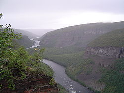
 View of the Sautso canyon | |
| Location | |
| Country | Norway |
| County | Troms og Finnmark |
| District | Alta, Kautokeino |
| City | Alta |
| Physical characteristics | |
| Source | South of Reisa National Park near the border with Finland and Troms og Finnmark |
| • location | Kautokeino, Troms og Finnmark, Norway |
| • coordinates | 69°04′50″N 22°23′02″E / 69.08056°N 22.38389°E |
| • elevation | 483 m (1,585 ft) |
| Mouth | Alta |
• location | Alta Municipality, Troms og Finnmark, Norway |
• coordinates | 69°58′10″N 23°22′24″E / 69.96944°N 23.37333°E |
• elevation | 0 m (0 ft) |
| Length | 240 km (150 mi) |
| Basin size | 7,390 km2 (2,850 sq mi) |
| Discharge | |
| • location | Alta |
| • average | 90 m3/s (3,200 cu ft/s) |
| • maximum | 1,200 m3/s (42,000 cu ft/s) |
Altaelva (Template:Lang-en;[1][2][3] Template:Lang-sme; Template:Lang-fkv) is the third-longest river in Troms og Finnmark county, Norway. The river begins in the mountains and lakes in Kautokeino Municipality, near the border with Troms og Finnmark county and Finland, just south of Reisa National Park. The 240-kilometre (150 mi) long river then runs northward into Alta Municipality where it flows out into the Altafjorden in the town of Alta. The river has carved out Sautso, one of the largest canyons in Europe on its way from the high Finnmarksvidda plateau down to the sea. The villages of Kautokeino and Masi are located along the river, in addition to the town of Alta.[4]
During the 1970s and 1980s, the river was the site of the Alta controversy regarding the construction of a hydroelectric power plant. The Alta power station was eventually built in 1987, creating the lake Virdnejávri on the river.[4]
The river is one of the best salmon rivers in Norway, known for its large-sized salmon. In older days, salmon up to 33 kilograms (73 lb) were recorded, and still fish up to 24 kilograms (53 lb) are caught.[5] In 2011, 1,082 salmon (7 kilograms (15 lb) or heavier) were caught on the river.[4]
Name
The Altaelva literally means the "Alta River" in English. The Northern Sami language version of the name is Álttáeatnu and the Kven language version of the name is Alattionjoki. The part of the river that is upstream (south) of the Alta dam is also called Kautokeinoelva, meaning the "Kautokeino River", since that part of the river lies in Kautokeino. That part of the river is also known as Guovdageaineatnu or Eatnu in the Northern Sami language.[4]
References
- ^ Proctor, James. 2015. Lapland. Bucks, UK: Bradt Travel Guides, p. 195.
- ^ Dalland, Øystein. 1997. The Last Big Dam in Norway: Whose Victory? In: Ann Danaiya Usher (ed.), Dams as Aid, pp. 41–58. London: Routledge, p. 48.
- ^ Chapralis, Jim C. 2002. Fishing Passion: A Lifelong Love Affair with Angling. Evanston, IL: AnglingMatters Press, p. 161.
- ^ a b c d Store norske leksikon. "Altaelva" (in Norwegian). Retrieved 2013-01-14.
- ^ http://www.nrk.no/24 kg salmon caught on fishing rod in Alta river July 2011
External links
 Media related to Altaelva at Wikimedia Commons


