Nive
Appearance
| Nive | |
|---|---|
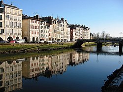
 Nive in Bayonne | |
 | |
| Location | |
| Country | |
| Physical characteristics | |
| Source | |
| • location | Pyrenees |
| • coordinates | 43°03′38″N 1°11′49″W / 43.06056°N 1.19694°W |
| Mouth | |
• location | Adour |
• coordinates | 43°29′38″N 1°28′27″W / 43.49389°N 1.47417°W |
| Length | 80 km (50 mi) |
| Basin size | 1,030 km2 (400 sq mi) |
| Basin features | |
| Progression | Adour→ Atlantic Ocean |
The Nive (Template:Lang-eu, Template:Lang-oc) is a French river that flows through the French Basque Country. It is a left tributary of the river Adour. The river's source in the Pyrenees in Lower Navarre. The river Nive was made famous by the Le petit Nicolas series.
Geography


The Nive proper is formed from three head rivers in Saint-Jean-Pied-de-Port:
- The Nive de Béhérobie (main stream)
- The Laurhibar
- The Nive d'Arnéguy.
The Nive passes through the towns of Estérençuby (Nive de Béhérobie), Saint-Jean-Pied-de-Port, Bidarray, Cambo-les-Bains, Ustaritz, Villefranque and Bayonne, where it flows into the Adour.
Principal tributaries
- Ezterrengibel or Esterenguibel
- Nive des Aldudes, from Saint-Étienne-de-Baïgorry
- Laka, from Ossès
- Baztan, from Bidarray
- Latsa, from Espelette
References
See also
External links
Wikimedia Commons has media related to Nive.
- (in French) Au fil des Nives
- (in French) Tour de la Haute vallée de la Nive
- (in French) Contrat de Rivière des Nives
