North and South Marine Parks
Appearance
| North and South Marine Parks | |
|---|---|
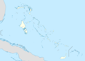
| Location | East of Andros, the Bahamas |
| Nearest city | Nassau |
| Coordinates | 24°52′29″N 77°53′20″W / 24.8748°N 77.8889°W[1] |
| Area | 5,000 acres (20 km2; 8 sq mi) |
| Established | 2002 |
| Governing body | Bahamas National Trust |
| bnt | |
The North and South Marine Parks are national parks off the eastern coast of Andros, the Bahamas. The parks were established in 2002 and have an area of 5,000 acres (20 km2; 8 sq mi).[2]
Flora and fauna
[edit]The parks contain a barrier reef with associated coral and other wildlife.[3]
References
[edit]- ^ a b "Andros Northern Marine Park in Bahamas". Protected Planet. Retrieved 4 January 2019. "Andros Southern Marine Park in Bahamas". Protected Planet. Retrieved 4 January 2019.
- ^ "North and South Marine Parks". The Bahamas National Trust. Archived from the original on 27 April 2019. Retrieved 4 January 2019.
- ^ "Exploring The Andros Barrier Reef". The Atlantis Blue Project Foundation. December 2015. Retrieved 4 January 2018.

