Mistrató
Appearance
Mistrato | |
|---|---|
Municipality and town | |
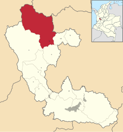
 Location of the municipality and town of Mistrato in the Risaralda Department of Colombia. | |
| Country | |
| Department | Risaralda Department |
| Area | |
| • Total | 690 km2 (270 sq mi) |
| Population (Census 2018[2]) | |
| • Total | 16,203 |
| • Density | 23/km2 (61/sq mi) |
| Time zone | UTC-5 (Colombia Standard Time) |
Mistrato (elevation 1900 m[3]) is a town and municipality in the Department of Risaralda, Colombia. The town is located about two hours west of Pereira.
References
- ^ "Municipalities of Colombia". statoids. Retrieved 26 April 2020.
- ^ "Censo Nacional de Población y Vivienda 2018" (in Spanish). DANE. Retrieved 26 April 2020.
- ^ D. Liverman; C. Pereira; B. Marker, eds. (2008). "Community participation in natural risk prevention: case histories from Columbia". Communicating Environmental Geoscience. Geological Society. p. 49. ISBN 1862392609.
{{cite book}}: Unknown parameter|authors=ignored (help)
5°18′N 75°53′W / 5.300°N 75.883°W


