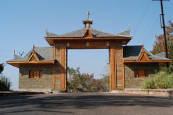
Indira Gandhi Rashtriya Manav Sangrahalaya
 Indira Gandhi Rashtriya Manav Sangrahalaya | |
 | |
| Location | Bhopal , India |
|---|---|
| Coordinates | 23°13′56″N 77°22′39″E / 23.232279°N 77.37761°E |
| Type | Anthropological museum |
| Website | www.igrms.gov.in |

Indira Gandhi Rashtriya Manav Sangrahalaya (IGRMS) or National Museum of Humankind or Museum of Man is an anthropology museum located in Bhopal, India, to present an integrated story of the evolution of man and culture with special reference to India. It spreads over an area of about 200 acres on the Shyamla Hills in the city.[1][2] This museum depicts the story of mankind in time and space. Located on Bhopal's upper lake, 'Rashtriya Manav Sangrahalaya' can be accessed either from Lake View Road or from another road near Demonstration School. IGRMS has a few permanent exhibitions, broadly categorized as a) Open-exhibitions, b) Indoor galleries (Veethi-Sankul and Bhopal Gallery) and c) Periodical/ Temporary exhibitions. It also has other exhibitions categorized as 1. Online exhibitions, 2. Travelling exhibitions, 3. Special exhibitions and 4. Ongoing exhibitions.
The following open-air exhibitions partially developed and opened for the public: Tribal Habitat. Coastal Village, Desert Village, Himalayan Village, Mythological Trail, Traditional Technology park.
The museum also has a regional centre for the South India region at Mysore in Karnataka.[3]
References
- ^ IGRMS website
- ^ "International Museum Day to be celebrated on May 18". The Times of India. 27 April 2013. Retrieved 12 May 2013.
- ^ "Seminar on tribal and analogous culture". The Hindu. 2 August 2010. Retrieved 12 May 2013.
External links
23°13′56″N 77°22′39″E / 23.232279°N 77.37761°E
