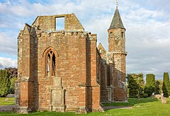
Fortrose
Fortrose
| |
|---|---|
 Fortrose Cathedral | |
Location within the Ross and Cromarty area | |
| Population | 1,590 (2016)[1] |
| OS grid reference | NH7256 |
| • Edinburgh | 118 mi (190 km) |
| • London | 449 mi (723 km) |
| Council area | |
| Lieutenancy area | |
| Country | Scotland |
| Sovereign state | United Kingdom |
| Post town | FORTROSE |
| Postcode district | IV10 |
| Dialling code | 01381 |
| Police | Scotland |
| Fire | Scottish |
| Ambulance | Scottish |
| UK Parliament | |
| Scottish Parliament | |
Fortrose (/fɔːrtˈroʊz/; Template:Lang-gd, Template:Lang-sco) is a town and former royal burgh in Highland, Scotland, United Kingdom.[2][3] It is on the Moray Firth, about 6 miles (10 km) north-east of Inverness. The town is known for its ruined 13th century cathedral, and as the home of the Brahan Seer. In the Middle Ages it was the seat of the bishopric of Ross, and formerly called Chanonry, for being the Chanory of Ross.[4] The cathedral was largely demolished in the mid-seventeenth century by Oliver Cromwell to provide building materials for a citadel at Inverness.[5] The vaulted south aisle, with bell-tower, and a detached chapter house (used as the tollbooth of Fortrose after the Reformation) remain. These fragments, though modest in scale, display considerable architectural refinement, and are in the care of Historic Scotland (no entrance charge). The burgh is a popular location for trying to spot bottlenose dolphins (see Chanonry Point) in the Moray Firth.
Fortrose shares a golf course with Rosemarkie. Set on the Chanonry Ness the course stretches out into the Moray Firth and offers good views of Fort George. The course is well known for its signature 4th Hole "Lighthouse". The lighthouse in question is the Chanonry Point lighthouse which was designed by Alan Stevenson and was first lit 15 May 1846.
Public buildings in Fortrose include a leisure centre, library and the only secondary school on the Black Isle, Fortrose Academy.
The correct pronunciation of the town's name in accordance with local usage is with the stress on the first syllable.
Etymology
The name Fortrose may conserve the ethonym Fortriu.[6]
Parliamentary burgh
Fortrose was a parliamentary burgh, combined with Inverness, Forres and Nairn, in the Inverness Burghs constituency of the House of Commons of the Parliament of Great Britain from 1708 to 1801 and of the Parliament of the United Kingdom from 1801 to 1918. The constituency was abolished in 1918 and the Fortrose component was merged into the then new constituency of Ross and Cromarty.
Fortrose Academy
Fortrose Academy is the only secondary school on the Black Isle. There are around 640 pupils enrolled. Notable former teachers include Mr A. Tait, who won the Teacher of the Year Award in Scotland, 2006. The rector of the school is Gavin Maclean.
Fortrose Library
Built into the school is Fortrose library, which is part of the Highland Libraries group. The library is regularly used by pupils in Fortrose Academy, for which the younger years take out books to participate in the "power readers" scheme, which involves pupils getting rewards for reading a certain number of books, and passing on to the next level. Due to the library's small size, the stock is always changing.
Black Isle Leisure Centre
Situated next to the school is the Black Isle Leisure Centre. It consists of a gym, and one single indoor court which has space for four badminton courts, four small basketball courts or one full sized basketball court. It also has goals at either end for football. Pupils of Fortrose Academy regularly have PE lessons in the Leisure Centre.
Transport
The A832 runs through the town.
There is a bus service from Inverness that runs half-hourly weekdays (with a few gaps for schools traffic). The buses continue hourly to Cromarty.
There was a railway station at Fortrose, which closed in 1951. The line it was situated on closed in 1960.
References
- ^ "Fortrose (Highland, Scotland, United Kingdom) - Population Statistics, Charts, Map, Location, Weather and Web Information". www.citypopulation.de. Retrieved 21 April 2019.
- ^ "Fortrose". The Gazetteer for Scotland. School of GeoSciences, University of Edinburgh and The Royal Scottish Geographical Society. Retrieved 17 June 2018.
- ^ The Online Scots Dictionary
- ^ John Ramsay McCulloch (1847). A Dictionary, Geographical, Statistical, and Historical, of the Various Countries, Places, and Principal Natural Objects in the World: Illustrated with Maps. Harper & Brothers. p. 921. Retrieved 17 June 2018.
- ^ The Scots Magazine. D.C. Thomson. 1956. p. 155. Retrieved 17 June 2018.
- ^ Rhys, Guto. "Approaching the Pictish language: historiography, early evidence and the question of Pritenic" (PDF). University of Glasgow. University of Glasgow.
Further reading
- Bond, Elizabeth (1814) Letters of a Village Governess. 2 vols. London: printed for the Author, by E. Blackader

