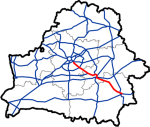
M5 highway (Belarus)
Appearance
You can help expand this article with text translated from the corresponding article in Russian. (February 2020) Click [show] for important translation instructions.
|
| M5 | |
|---|---|
| Магістраль М5 | |
 | |
| Route information | |
| Part of | |
| Length | 296 km (184 mi) |
| Major junctions | |
| Northwest end | Intersection |
| Southeast end | Homyel |
| Location | |
| Country | Belarus |
| Major cities | Babruysk, Zhlobin |
| Highway system | |
М5 highway connects Minsk with Homyel. It is a part of European route E271. The highway is around 296 km long. It shares first 12 km with the M4 motorway, branches off it near Privolnyi and runs south-east. Near Babruysk it crosses with many regional roads. Near Homyel it connects to the M8 highway. All road is dual carriageway.
| Distance (approx.) |
Name | Other roads | |
|---|---|---|---|
| 0 km | Minsk | ||
| 10 km | |||
| 12 km | |||
| 29 km | Svislach | ||
| 49 km | Maryina Horka | ||
| 90 km | Asipovichy | ||
| 121 km | Babruysk | ||
| 123 km | Babruysk | ||
| 134 km | |||
| 137 km | |||
| 146 km | Babruysk | ||
| 151 km | Babruysk | ||
| 155 km | Babruysk | ||
| 188 km | |||
| 203 km | Zhlobin | ||
| 206 km | Zhlobin | ||
| 242 km | Buda-Kashalyova | ||
| 285 km | |||
| 296 km | Homyel |

