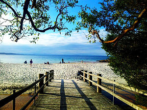
Greenpatch Point

Greenpatch is a locality in the Jervis Bay Territory in Australia. It's located inside the Boodere National Park.
This local has several unbelivable beaches. These beaches has one crystal and clear water, the sand is blindingly white and the wild life there is very friendly. It's possible and very common to see kangaroos sunning themselves.
Amenities
Usually the amenities there include:
- Fresh water;
- Toilets
- Hot water showers;
- Sheltered BBQ areas.
What is important to know? There is a communal fire area in the ‘D’ section of the park, and firewood is provided. Also, it's very advisable to bring your own portable gas BBQ.[1]
Geography
Greenpatch is located on Aboriginal Land within the Booderee National Park. It is located in close proximity to HMAS Creswell and Jervis Bay Village. Greenpatch beach is approximately 1.5 kilometres (0.93 mi) long. The Guinness Book of Records reports Jervis Bay as having the whitest sand in the world.[2]

Wildlife
Greenpatch is home to many different kinds of Australian native flora and fauna, including kangaroos, kookaburras, rosellas, lorikeets and wombats and many more.
See also
External links
References
- ^ "Green Patch Camp Ground". Complete Campsite. 22 March 2016.
- ^ "Gazing onto the world's whitest sands". Sydney: The Sydney Morning Herald. 1 January 2006. Retrieved 13 April 2011.
