Wingan River, Victoria
| Wingan River Victoria | |||||||||||||||
|---|---|---|---|---|---|---|---|---|---|---|---|---|---|---|---|
| Coordinates | 37°37′46″S 149°31′48″E / 37.6295587°S 149.5300448°E | ||||||||||||||
| Population | 0 (2016 census)[1] | ||||||||||||||
| Postcode(s) | 3891 | ||||||||||||||
| Location |
| ||||||||||||||
| LGA(s) | Shire of East Gippsland | ||||||||||||||
| State electorate(s) | Gippsland East | ||||||||||||||
| Federal division(s) | Gippsland | ||||||||||||||
| |||||||||||||||
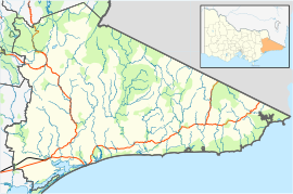
Wingan River is a locality in the Shire of East Gippsland, Victoria, Australia. It is situated on the river of the same name.[2] In the 2016 census, Wingan River had a population of zero.[1]
The area is heavily forested and almost entirely contained within state forests or national parks, variously the Drummer State Forest (northern part), Alfred National Park (western part) and the Wingan State Forest and Croajingolong National Park (remaining areas). The Princes Highway runs through the locality, which has few other roads.[2] The Wingan Inlet Campground is located along Wingan Beach.[3][4]
Gold mining was conducted in the area during the 1910s. A state battery opened in 1916, but by 1932 was reported to have been "rusting away" for many years.[5][6][7][8] The first Wingan River Post Office opened on 1 November 1936 and closed on 30 November 1943, while the second opened on 15 May 1947 and closed on 30 June 1979.[9]
The locality was badly damaged during the 2019–20 Australian bushfire season, with a fire that began at Wingan River in late December subsequently burning through to the coastal town of Mallacoota on New Year's Day.[10][11]
References
- ^ a b Australian Bureau of Statistics (27 June 2017). "Wingan River (SSC)". 2016 Census QuickStats. Retrieved 1 February 2020.
- ^ a b "Wingan River (entry 103645)". VICNAMES. Government of Victoria. Retrieved 1 February 2020.
- ^ "Wingan". beachsafe.org.au. Retrieved 1 February 2020.
- ^ "Wingan Inlet Campground". Parks Victoria. Retrieved 1 February 2020.
- ^ "WINGAN RIVER". Snowy River Mail. Victoria, Australia. 19 November 1915. p. 3 (WEEKLY). Retrieved 1 February 2020 – via Trove.
- ^ "REEF ON THE WINGAN". Snowy River Mail. Victoria, Australia. 22 November 1918. p. 3 (WEEKLY). Retrieved 1 February 2020 – via Trove.
- ^ "Opening of State Battery at Wingan River". The Twofold Bay Magnet : And South Coast And Southern Monaro Advertiser. New South Wales, Australia. 7 February 1916. p. 5. Retrieved 1 February 2020 – via Trove.
- ^ "BABY ENDEAVOR MINE". The Herald. Victoria, Australia. 28 June 1932. p. 16. Retrieved 1 February 2020 – via Trove.
- ^ "Wingan River". Post Office Reference. Premier Postal. Retrieved 1 February 2020.
- ^ "The sky turned black". The Age. 31 December 2019.
- ^ "Flames bearing down on Wingan River". Herald Sun. 1 January 2020. Retrieved 1 February 2020.


