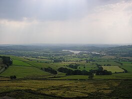
Tittesworth reservoir
Appearance
This article includes a list of general references, but it lacks sufficient corresponding inline citations. (September 2016) |
| Tittesworth Reservoir | |
|---|---|
 | |
| Location | Staffordshire |
| Coordinates | 53°08′02″N 2°00′47″W / 53.134°N 2.013°W |
| Lake type | reservoir |
| Primary inflows | River Churnet |
| Primary outflows | River Churnet |
| Managing agency | Severn Trent Water |
| Built | 1963 |
| Max. length | 1.8 kilometres (1.1 mi) |
| Max. width | 0.6 kilometres (0.37 mi) |
| Surface area | 760,000 square metres (190 acres) |
| Water volume | 6,440,000m³ (1.4 billion gallons) |
| Shore length1 | 6.6 kilometres (4.1 mi) |
| 1 Shore length is not a well-defined measure. | |
Tittesworth Reservoir is a water storage reservoir near Leek, Staffordshire, England, fed by the River Churnet. The reservoir and associated water treatment works are owned and operated by Severn Trent Water. The reservoir was built in 1858 and extended in 1963.[1] Tittesworth is the second largest reservoir by volume in the county of Staffordshire.
