Oranje, Netherlands
Appearance
52°54′N 6°27′E / 52.900°N 6.450°E
Oranje | |
|---|---|
 | |
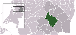
 Oranje in the municipality of Midden-Drenthe. | |
 Oranje in the municipality of Midden-Drenthe. | |
| Country | Netherlands |
| Province | Drenthe |
| Municipality | Midden-Drenthe |
Oranje is a small town in the Dutch province of Drenthe. It is a part of the municipality of Midden-Drenthe, and lies about 13 km southwest of Assen.
History
The statistical area "Oranje", which also can include the surrounding countryside, has a population of around 110.[1] After an initial grudging agreement from the inhabitants to house 700 refugees in a holiday park in their village, on 6 October 2015 the government unilaterally increased this number to 1,400 to be accommodated immediately.[2] This resulted in outrage and short term blockades of the village by the inhabitants.[3]
References
- ^ Statistics Netherlands (CBS), Statline: Kerncijfers wijken en buurten 2018. As of 27 July 2018.
- ^ "Blokkades opgeheven, bussen rijden Oranje binnen - Binnenland - Voor nieuws, achtergronden en columns". De Volkskrant.
- ^ Berg, Jurre Van den. "En weg is het 'Oranjegevoel' - Binnenland - Voor nieuws, achtergronden en columns". De Volkskrant.
