Předslavice
Předslavice | |
|---|---|
Municipality | |
 | |
| Coordinates: 49°08′N 13°56′E / 49.133°N 13.933°E | |
| Country | |
| Region | South Bohemian |
| District | Strakonice |
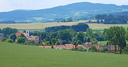
Předslavice is a village in the South Bohemian Region, Czech republic. The village is situated approximately 5 km east of Volyně in the hilly landscape near the Šumava mountains. It has 240 inhabitants living in 7 local parts: Předslavice, Beneda, Kalce, Úlehle (Oulehle), Všechlapy, Marčovice and Kakovice.
A famous native of Marčovice was the priest, patriot and regional historian František Teplý (1867–1945).
External links
- https://archive.is/20130210074322/http://www.pamatniknarodnihopisemnictvi.cz/cs/pruvodce-po-fondech-la-seznamy.php?id=1777&sk=t
- http://www.predslavice.cz/
- http://portal.gov.cz/wps/portal/_s.155/696?kam=urad&kod=60340
- http://www.statnisprava.cz/rstsp/ciselniky.nsf/i/551635
Wikimedia Commons has media related to Předslavice.

