Răut
| Răut | |
|---|---|
 Răut, Raionul Orhei | |
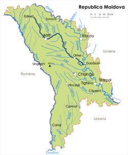
 Map of the Răut River (in Romanian or Moldavian) | |
| Location | |
| Country | Moldova |
| Physical characteristics | |
| Mouth | Dniester |
• coordinates | 47°14′40″N 29°08′50″E / 47.2445°N 29.1471°E |
| Length | 286 km (178 mi) |
| Basin size | 7,760 km2 (3,000 sq mi) |
| Basin features | |
| Progression | Dniester→ Dniester Estuary→ Black Sea |
Răut, also referred to as Reut (Romanian: Răut, Ukrainian and Russian: Реут (Reut), Yiddish: רעװעט (Revet)) is a river in Moldova, a right tributary of Dniester. Răut, generally navigable until 18-19th century, is navigable today only by small recreational boats.
The towns Bălți, Orhei and Florești are located by the river.
Wikimedia Commons has media related to Răut River.
