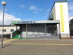
Ainosato-Kyōikudai Station
Ainosato-Kyōikudai Station あいの里教育大駅 | |||||
|---|---|---|---|---|---|
 The south entrance in October 2012 | |||||
| General information | |||||
| Location | Kita-ku, Sapporo, Hokkaido Japan | ||||
| Operated by | |||||
| Line(s) | ■ Sasshō Line (Gakuen Toshi Line) | ||||
| Distance | 13.6 km from Sōen | ||||
| Platforms | 2 side platforms | ||||
| Tracks | 2 | ||||
| Other information | |||||
| Status | Staffed | ||||
| Station code | G10 | ||||
| Website | www | ||||
| History | |||||
| Opened | 1 November 1986 | ||||
| Electrified | 1 June 2012 | ||||
| Passengers | |||||
| FY2014 | 3,898 daily | ||||
| |||||
Ainosato-Kyōikudai Station (あいの里教育大駅, Ainosato-Kyōikudai-eki) is a railway station on the Sasshō Line in Kita-ku, Sapporo, Hokkaido, Japan, operated by the Hokkaido Railway Company (JR Hokkaido). The station is numbered G10.[1]
Lines
Ainosato-Kyōikudai Station is served by the Sasshō Line (Gakuen Toshi Line) from Sapporo to Shin-Totsukawa.
Station layout
The station has two side platforms serving two tracks.[2] The station has automated ticket machines, automated turnstiles which accept Kitaca,[3] and a "Midori no Madoguchi" staffed ticket office.
Platforms
| 1 | ■ Sasshō Line | for Sōen and Sapporo |
| 2 | ■ Sasshō Line | for Hokkaidō-Iryōdaigaku and Shin-Totsukawa |
-
View of the platforms in December 2004
Adjacent stations
| « | Service | » | ||
|---|---|---|---|---|
| Sasshō Line | ||||
| Takuhoku (G09) | Local | Ainosato-kōen (G11) | ||
History
The station opened on 1 November 1986.[4] With the privatization of Japanese National Railways (JNR) on 1 April 1987, the station came under the control of JR Hokkaido.[4]
Electric services commenced from 1 June 2012, following electrification of the line between Sapporo and Hokkaidō-Iryōdaigaku.[2]
Surrounding area
- Hokkaido University of Education Sapporo Campus
References
- ^ "JR Hokkaido Route Map" (PDF). Hokkaido Railway Company. Archived from the original (PDF) on 7 December 2016. Retrieved 26 November 2016.
- ^ a b Nomura, Yukihiro (August 2012). "札沼線電化事業の概要" [Outline of Sasshō Line Electrification Project]. Tetsudō Daiya Jōhō Magazine. Vol. 41, no. 340. Japan: Kōtsū Shimbun. pp. 4–9.
- ^ "Service Range Kitaca". JR Hokkaido. Archived from the original on 19 November 2016. Retrieved 25 November 2016.
- ^ a b Ishino, Tetsu, ed. (1998). 停車場変遷大辞典 国鉄・JR編 [Station Transition Directory - JNR/JR]. Vol. II. Japan: JTB. p. 832. ISBN 4-533-02980-9.
External links
- Station information and map (in Japanese)


