Cothen
Appearance
Cothen | |
|---|---|
Town | |
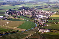
 Cothen from the air | |
 | |
 The village (darkgreen) and the statistical district (lightgreen) of Cothen in the municipality of Wijk bij Duurstede. | |
| Coordinates: 51°59′46″N 5°18′35″E / 51.99611°N 5.30972°E | |
| Country | Netherlands |
| Province | Utrecht |
| Municipality | Wijk bij Duurstede |
| Population (2003) | |
| • Total | 3,000 |
| Time zone | UTC+1 (CET) |
| • Summer (DST) | UTC+2 (CEST) |
Cothen is a town in the Dutch province of Utrecht. It is a part of the municipality of Wijk bij Duurstede, and lies about 10 km (6 mi) southeast of Houten.
In 2001, the town of Cothen had 2269 inhabitants. The built-up area of the town was 0.42 km2 (0 sq mi), and contained 890 residences.[1] Including both the village itself and the surrounding area, the statistical district of Cothen has about 2940 inhabitants.[2]
The skyline of Cothen is characterized by a church and a windmill called Oog In 't Zeil.
History
The village used to be a separate municipality. In 1996, it became a part of Wijk bij Duurstede.
References
- ^ Statistics Netherlands (CBS), Bevolkingskernen in Nederland 2001 [1]. Statistics are for the continuous built-up area.
- ^ Statistics Netherlands (CBS), Gemeente Op Maat 2004: Wijk bij Duurstede [2][permanent dead link].
External links
Wikimedia Commons has media related to Cothen.
- Template:Kuyper Map of the former municipality in 1868.

