
Rubottom, Oklahoma
Rubottom | |
|---|---|
 Rubottom Location within the state of Oklahoma  Rubottom Rubottom (the United States) | |
| Coordinates: 33°56′25″N 97°27′25″W / 33.94028°N 97.45694°W | |
| Country | United States |
| State | Oklahoma |
| County | Love |
| Time zone | UTC-6 (Central (CST)) |
| • Summer (DST) | UTC-5 (CDT) |
Rubottom is an unincorporated community in Love County, Oklahoma, United States.[1]
A post office was established at Rubottom, Indian Territory on Aug. 14, 1902. It was named for William P. Rubottom, a prominent landowner and cotton gin operator.[2] At the time of its founding, Rubottom was located in Pickens County, Chickasaw Nation.[3]
The community is part of the Turner Independent School District.
References
- ^ "Rubottom". Geographic Names Information System. United States Geological Survey, United States Department of the Interior.
- ^ George H. Shirk. Oklahoma Place Names (Norman: University of Oklahoma Press, 1965), p. 183.
- ^ Charles Goins, Historical Atlas of Oklahoma (Norman: University of Oklahoma Press, 2006), plate 105.
Municipalities and communities of Love County, Oklahoma, United States | ||
|---|---|---|
| City | 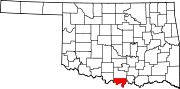 | |
| Towns | ||
| CDP | ||
| Other communities | ||
| Indian reservation | ||
| Footnotes | ‡This populated place also has portions in an adjacent county or counties | |
This Oklahoma state location article is a stub. You can help Wikipedia by expanding it. |