
Milberger, Kansas
Milberger, Kansas | |
|---|---|
 | |
 Milberger  Milberger | |
| Coordinates: 38°42′43″N 98°54′44″W / 38.71194°N 98.91222°W | |
| Country | United States |
| State | Kansas |
| County | Russell |
| Founded | 1884 |
| Elevation | 1,854 ft (565 m) |
| Time zone | UTC-6 (CST) |
| • Summer (DST) | UTC-5 (CDT) |
| ZIP code | 67665 |
| Area code | 620 |
| FIPS code | 46475 |
| GNIS ID | 475411 [1] |
Milberger is an unincorporated community in Lincoln Township, Russell County, Kansas, United States.[2] It is located about 10.5 miles south of Russell.
History
Volga German colonists founded Milberger in 1884. Predominantly Lutheran, they established several churches in and around the community, most of which closed by 1980.[3][4] A rural post office operated in Milberger from 1903 to 1911.[5]
Geography
Milberger is located at 38°42′43″N 98°54′44″W / 38.71194°N 98.91222°W (38.7119562, -98.9123098) at an elevation of 1,854 feet (565 m).[1] It lies on the west side of Landon Creek roughly 4.5 miles (7 km) south of the Smoky Hill River in the Smoky Hills region of the Great Plains.[6][7] Milberger is approximately 3.5 miles (6 km) west of U.S. Route 281, 10.5 miles (17 km) south of Interstate 70, and 12 miles (20 km) south-southwest of Russell, the county seat.[7]
Transportation
Milberger lies at the intersection of 182nd Street, a paved county road which runs north-south, and Michaelis Road, an unpaved county road which runs east-west.[7][8]
References
- ^ a b "US Board on Geographic Names". United States Geological Survey. 2007-10-25. Retrieved 2008-01-31.
- ^ "General Highway Map - Russell County, Kansas" (PDF). Kansas Department of Transportation. 1975. Retrieved 2010-12-12.
- ^ Keel, William D. (2006). "Deitsch, Däätsch, Düütsch, and Dietsch: The Varieties of Kansas German Dialects after 150 Years of German Group Settlement in Kansas". University of Kansas. Retrieved 2010-08-15.
- ^ Bauer, Reuben A. (2004). "German Hymns Heard Again". Archived from the original on 2011-06-22. Retrieved 2010-08-15.
- ^ "Post Offices in Kansas". Kansas State Historical Society. Retrieved 2010-08-15.
- ^ "2003-2004 Official Transportation Map" (PDF). Kansas Department of Transportation. 2003. Retrieved 2010-12-12.
- ^ a b c "General Highway Map - Russell County, Kansas" (PDF). Kansas Department of Transportation. 2010-10-01. Retrieved 2010-12-12.
- ^ "Milberger, KS 67665". Google Maps. Retrieved 2010-12-12.
Further reading
External links
Municipalities and communities of Russell County, Kansas, United States | ||
|---|---|---|
| Cities | 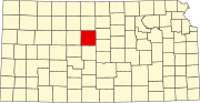 | |
| Unincorporated communities | ||
| Ghost towns | ||
| Townships | ||
| Footnotes | ‡This community also has portions in an adjacent county or counties. | |