Jump to content

Fale, Tokelau

Coordinates: 9°23′05″S 171°14′54″W / 9.3846°S 171.2483°W / -9.3846; -171.2483
From Wikipedia, the free encyclopedia

This is an old revision of this page, as edited by Hmains (talk | contribs) at 22:15, 31 May 2020 (removed Category:Islands claimed under the Guano Islands Act; added Category:Pacific islands claimed under the Guano Islands Act using HotCat). The present address (URL) is a permanent link to this revision, which may differ significantly from the current revision.

Fale
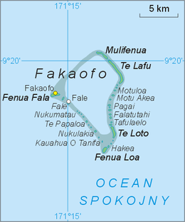
Map of Fakaofo Atoll, with the names of the islets in Tokelauan and the name of the Pacific Ocean in Polish
Geography
Coordinates9°23′05″S 171°14′54″W / 9.3846°S 171.2483°W / -9.3846; -171.2483
ArchipelagoFakaofo
Administration

Fale is an islet of the Fakaofo island group of Tokelau. The main settlement in the group is located on the island.

References