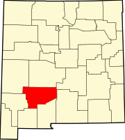
Arrey, New Mexico
Appearance
Arrey, New Mexico | |
|---|---|
Census-designated place | |
| Coordinates: 32°50′55″N 107°19′09″W / 32.84861°N 107.31917°W | |
| Country | United States |
| State | New Mexico |
| County | Sierra |
| Area | |
• Total | 0.790 sq mi (2.05 km2) |
| • Land | 0.790 sq mi (2.05 km2) |
| • Water | 0 sq mi (0 km2) |
| Elevation | 4,180 ft (1,270 m) |
| Population | |
• Total | 232 |
| • Density | 290/sq mi (110/km2) |
| Time zone | UTC-7 (Mountain (MST)) |
| • Summer (DST) | UTC-6 (MDT) |
| Area code | 575 |
| GNIS feature ID | 898717[2] |
Arrey is a census-designated place in Sierra County, New Mexico, United States. It lies about 22 miles south of Truth or Consequences. As of the 2010 census, its population was 232.[1]
In 1890, the town was founded as Bonito when several Hispanic families made a deal with a cattle agent to settle here. The land was then deeded to the Butte Land and Cattle Company after the land was proved. In 1901, a post office was established, with Urbano Arrey as the first postmaster; he gave his name to the community. Today descendants of the original homesteaders still live in the community.[3]
References
- ^ a b c "2010 Census Gazetteer Files - Places: New Mexico". U.S. Census Bureau. Archived from the original on July 14, 2014. Retrieved November 9, 2014.
- ^ "Arrey". Geographic Names Information System. United States Geological Survey, United States Department of the Interior.
- ^ Julyan, Robert (1996). The Place Names of New Mexico. University of New Mexico Press. p. 22. ISBN 0826316891.


