Kohtla Parish
Appearance
Kohtla Parish
Kohtla vald | |
|---|---|
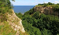
 Baltic Klint near Saka | |
 Kohtla Parish within Ida-Viru County. | |
| Country | |
| County | |
| Administrative centre | Järve |
| Area | |
| • Total | 101 km2 (39 sq mi) |
| Population | |
| • Total | 1,640 |
| • Density | 16/km2 (42/sq mi) |
| Website | www.kohtlavv.ee |
Kohtla Parish (Estonian: Kohtla vald) was an Estonian municipality located in Ida-Viru County. It has a population of 1640 (2014) and an area of 101 km².
Villages
Amula, Järve, Kaasikaia, Kaasikvälja, Kabelimetsa, Kohtla, Kukruse, Mõisamaa, Ontika, Paate, Peeri, Roodu, Saka, Servaääre, Täkumetsa, Valaste, Vitsiku.
External links
- Official website (in Estonian)
59°21′N 27°11′E / 59.350°N 27.183°E


