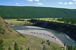
Oka (Angara)
Appearance
| Oka | |
|---|---|
 | |
 | |
| Location | |
| Country | Russia |
| Physical characteristics | |
| Source | |
| • location | Sayan Mountains |
| Mouth | Angara |
• coordinates | 55°30′55″N 102°20′54″E / 55.51528°N 102.34833°E |
| Length | 630 km (390 mi) |
| Basin size | 34,000 km2 (13,000 sq mi) |
| Basin features | |
| Progression | Angara→ Yenisey→ Kara Sea |
The Oka (Template:Lang-ru, Template:Lang-bua) is a river in Siberia, left tributary of the Angara. It originates in the Sayan Mountains in western Buryatia and flows through Irkutsk Oblast. It discharges into the Bratsk reservoir. It is 630 kilometres (390 mi) long, and has a drainage basin of 34,000 square kilometres (13,000 sq mi).[1]
References
- ^ "Река Ока (Аха) in the State Water Register of Russia". textual.ru (in Russian).
