
Muir Pass
| Muir Pass | |
|---|---|
 | |
| Elevation | 11,955 ft (3,644 m) |
| Traversed by | John Muir Trail, Pacific Crest Trail |
| Location | Fresno County, California, United States |
| Range | Sierra Nevada |
| Coordinates | 37°06′42″N 118°40′14″W / 37.11167°N 118.67056°W [1] |
Muir Pass is a mountain pass in the Sierra Nevada of California, United States, in Kings Canyon National Park. It is named for John Muir.[1]
The pass is near the midway point of the John Muir Trail and around mile 841 of the Pacific Crest Trail. It crosses the Goddard Divide between Mount Solomons and Mount Warlow,[1] at an elevation of 11,955 feet (3,644 m). The Muir Hut, built by the Sierra Club, is at the summit of the pass. Although the grade is gentle from both directions, snow can persist well into the summer, obscuring the trail for miles.
-
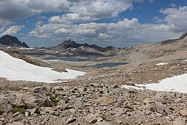 View of Lake McDermand and Wanda Lake, ascending the pass
 -
 The Muir Hut
 -
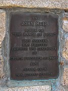 Commemorative on the Hut
 -
 Inside the hut


Notes
- ^ a b c "Muir Pass". Geographic Names Information System. United States Geological Survey, United States Department of the Interior. Retrieved 2008-09-12.
This Fresno County, California-related article is a stub. You can help Wikipedia by expanding it. |