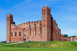
Radzyń Chełmiński
Appearance
Radzyń Chełmiński | |
|---|---|
 Castle Ruins | |
| Coordinates: 53°23′8″N 18°56′11″E / 53.38556°N 18.93639°E | |
| Country | |
| Voivodeship | Kuyavian-Pomeranian |
| County | Grudziądz |
| Gmina | Radzyń Chełmiński |
| Area | |
| • Total | 1.78 km2 (0.69 sq mi) |
| Population (2006) | |
| • Total | 1,915 |
| • Density | 1,100/km2 (2,800/sq mi) |
| Postal code | 87-220 |
| Website | http://www.radzynchelminski.pl |
Radzyń Chełmiński (Polish pronunciation: [ˈrad͡zɨɲ xɛu̯ˈmʲiɲskʲi]; German: Rehden) is a town in Grudziądz County, Kuyavian-Pomeranian Voivodeship, Poland, with 1,946 inhabitants (2004).
The town contains the ruins of a medieval Ordensburg castle built by the Teutonic Knights.
Points of interest


References
![]() Media related to Radzyń Chełmiński at Wikimedia Commons
Media related to Radzyń Chełmiński at Wikimedia Commons


