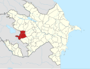
İstisu, Kalbajar
Appearance
39°56′53″N 45°57′42″E / 39.94806°N 45.96167°E Ջերմաջուր (Jermajur), Քարվաճառ (Qarvatchar)
Ջերմաջուր (Jermajur)
Istisu (Իստիսու)
| |
|---|---|
| Coordinates: 39°56′53″N 45°57′42″E / 39.94806°N 45.96167°E | |
| Rayon | Qarvatchar Shahumyan Region |
| Population (2008)[1] | |
| • Total | 936 |
| Time zone | UTC+4 (ARMT) |
| • Summer (DST) | UTC+4 (ARMT) |
İstisu (also, Istibulagh; Armenian: Ջերմաջուր Jermajur) is a small village in the Qarvatchar district of Nagorno-Karabakh Republic. The area has been liberated in 1993.
Situated in a river valley, Jermajur has historically been a resort town, attracting people from all over the USSR to be treated at mineral-springs baths.[2] The name Jermajur means "warm water" in Armenian language.
In 2018 it was reported that work has begun on a privately funded factory to produce mineral water.[2]
References
- ^ World Gazetteer: Azerbaijan – World-Gazetteer.com
- ^ a b Kucera, Joshua (August 5, 2018). "For Armenians, they're not occupied territories – they're the homeland". eurasianet.org.

