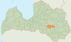
Krustpils Municipality
Krustpils Municipality
Krustpils novads | |
|---|---|
 | |
| Country | |
| Formed | 2009 |
| Centre | Jēkabpils (extraterritorially) |
| Government | |
| • Chairman | Kārlis Pabērzs (V) |
| Area | |
| • Total | 812.2 km2 (313.6 sq mi) |
| Population (2009)[2] | |
| • Total | 6,827 |
| • Density | 8.4/km2 (22/sq mi) |
| Website | www |
Krustpils Municipality (Latvian: Krustpils novads) is a municipality in Latgale, Latvia. The municipality was formed in 2009 by merging Atašiene parish, Krustpils parish, Kūkas parish, Mežāre parish, Varieši parish and Vīpe parish. The administrative centre located in Jēkabpils city, which is not included in the territory of the municipality.
Parts of Teiči Nature Reserve are located in Krustpils Municipality.
See also
References
56°30′N 25°51′E / 56.500°N 25.850°E


