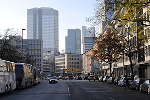
Berliner Straße (Frankfurt am Main)
Appearance
 | |
|---|---|
 | |
| Former name(s) | Schnurgasse |
| Location | Mitte/Paulskirche |
| Nearest metro station | Dom/Römer (Frankfurt U-Bahn U4) |
| Coordinates | 50°06′42″N 8°40′56″E / 50.1118°N 8.6821°E |
| West end | Theatertunnel |
| Major junctions | Kornmarkt, Paulsplatz (Neue Kräme), Domstraße-Hasengasse |
| East end | Börneplatz |
| Construction | |
| Construction start | 1952 |
| Inauguration | 16 November 1953 |
Berliner Straße is a major street in the city centre of Frankfurt am Main. It was built after the Bombing of Frankfurt am Main in World War II along the route of the old Schnurgasse.
