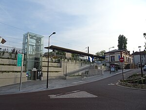
Viroflay Rive Droite station
Appearance
| Transilien commuter rail station | |||||||||||
 | |||||||||||
| General information | |||||||||||
| Location | 1 Place Stalingrad, 78220 Viroflay | ||||||||||
| Coordinates | 48°48′20″N 2°10′06″E / 48.8056°N 2.1683°E | ||||||||||
| Owned by | RFF | ||||||||||
| Line(s) | |||||||||||
| Platforms | 4 | ||||||||||
| Tracks | 2 railway + 2 Translohr | ||||||||||
| Connections | |||||||||||
| Construction | |||||||||||
| Depth | 114 metres (374 ft) | ||||||||||
| Platform levels | 1: 0: -1: Mezzanine haute -2 -3: Mezzanine basse -4: | ||||||||||
| Other information | |||||||||||
| Station code | 8738288 | ||||||||||
| Fare zone | 3 | ||||||||||
| History | |||||||||||
| Opened | 18 July 1840 | ||||||||||
| Electrified | 1976 | ||||||||||
| Services | |||||||||||
| |||||||||||
Viroflay-Rive-Droite is a railway station in the commune of Viroflay (department of Yvelines). It is in the Île-de-France region of France and is part of the Transilien rail network, on the Paris-Saint-Lazare – Versailles-Rive-Droite line. It is also an underground tram-on-tyres stop on line 6.
The name "Rive-Droite" refers to the trains' Paris destination (Saint-Lazare) being on the right bank of the Seine.
The Transilien & tramway platforms are connected by an IMEM Ascenseurs lift.
References
- ^ Beno (27 July 2017). "Expensive Eurostar adventure to Paris". Retrieved 18 August 2017 – via YouTube.
External links
- Viroflay Rive Droite station at Transilien, the official website of SNCF (in French)
